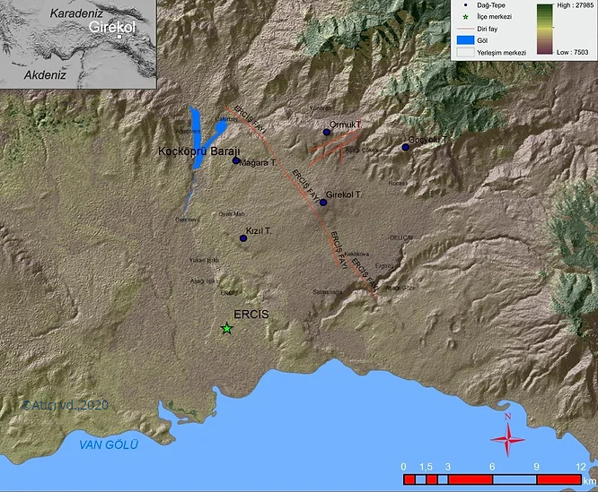
Girekol Tepe
- Volcano type: Shield
- Volcano number: 213022
- Latitude: 39.104°N
- Longitude: 43.426°E
- Elevation: 2145 m
- Distance to Ankara: >900 km
- Closest city: Erciş, <10 km
- Population within 5 km: 1,449
- Population within 10 km: 8,524
- Population within 30 km: 168,136
- Population within 100 km: 1,614,661
Girekol Tepe is one of many volcanoes of various sizes in the Eastern Anatolia region. It is one of the Quaternary volcanoes formed by the effect of Eastern Anatolian neotectonics. Girekol Tepe, a small shield type volcano, consists of basaltic lava flows and pyroclastic rocks. The Erciş fault located in the region played an important role in the settlement of the volcano. The Quaternary Girekol volcano was formed as a result of a basic alkaline volcanism. Volcanic products with alkali basalt and paleosoil composition are aged between 1.08 My and 0.36 My according to K / Ar age data (Lebedev et al., 2010).
The age of its most recent activity is uncertain, with possible Holocene activity.
References
Bozkurt, A., Hepşen, N., Sav, H. 2018. 1/100.000 Ölçekli Açınsama Nitelikli Türkiye Jeoloji Haritaları Serisi Ağrı J50 Paftası, Ankara: MTA Yayınları.
Global Volcanism Program, 2013. Girekol (213022) in Volcanoes of the World, v. 4.7.7. Venzke, E (ed.). Smithsonian Institution. Downloaded 18 Apr 2019 (https://volcano.si.edu/volcano.cfm?vn=213022).